Offline Topo Maps app for iPhone and iPad
4.8 (
4288 ratings )
Travel
Navigation
Developer:
TrailBehind
9.99 USD
Current version:
6.4.2, last update: 6 years ago
First release : 11 Jun 2010
App size: 47.5 Mb
►► WARNING - DOWNLOAD THE NEW APP INSTEAD
Instead of buying this app, please download the new Gaia GPS app. You can find it by searching for "Gaia GPS" - then scroll down and download the app with the gold border.
Were maintaining Offline Topo Maps for existing users, but our work is focused on the new app.
* * *
Offline Topo Maps (OTM) is a simpler version of our full-featured backcountry app, Gaia GPS.
OTM is the best simple topo app on the App Store, with the best maps, and the best support. Get in touch with the six+ hikers that develop OTM at [email protected]
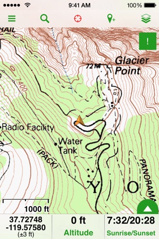
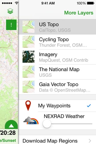
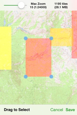
* download maps of the entire world
- USGS topo maps and aerial imagery
- OpenStreetMap-based topo and road maps of the world
- USGS topos for Alaska and NRCan topos for Canada
- highest resolution USGS topos on the App Store
* fast, functional, stable, and easy-to-use for even novice hikers
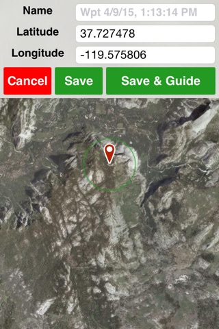
* mark waypoints and get guidance to and from places
* use metric, imperial, or nautical units
* display coordinates in Decimal, UTM, MGRS, DMS, or Decimal Minutes
* fully auto-rotatable for widescreen maps and other views
Warning: Continued use of GPS running in the background can dramatically decrease battery life.
Pros and cons of Offline Topo Maps app for iPhone and iPad
Offline Topo Maps app good for
This app has travelled a lot with me. Using it in the alps showed to me the precise mapping capabilities, loading all the map tiles before you go is an absolute killer feature.
What I love about this app most is that it doesnt cost me anything when Im in a foreign country. Before I travel, I save the maps that I need and use them when I get there. Also, I love to use this app when bicycling. It is much more accurate then any bicycle maps Ive ever seen. This app however doesnt replace topographic mountain maps...but almost does!
Especially the offline option saved me lots of roaming money. Use it all over the globe. Thanks a lot for never being lost again!
I am very happy that this app offers to use diverse maps sources which other map apps dont offer. I use now the Alaska topo maps offline, I did not find another app serving that purpose.
Ive used this out in the field, and it has saved me a few times. It has also led me astray by showing me some trails that actually did not exist. Not perfect yet. Having written that, there is not another app that I would use in the field.
Can be usefull very cool app works as advertised if your a hiker casual or pro this is a must have.
Some bad moments
I bought the app just to see that Europe is not supported because of licensing problems. You just see a big grey box where there is supposed to be a continent. This was not mentioned before. Because I only need Europe, I contacted the guys immediately afterwards to return my purchase and get my money back but the never replied. Complete waste of money. Thanks for nothing!
So far , I feel Ive wasted my money. This may change once Ive struggled with it more; if so, Ill come back and change the rating.
Interface is NOT intuitive at all. I cant (so far) perceive how to distinguish a map that is resident on my device from what the app is accessing online. This is important for me to make sure, when planning, that I will have the maps I need once out of cell reach. Took. me 10 minutes to find the instructions, which are under the "help" tab. And the only actual maps that look like they will be useful (of the three types available) will be the topo maps--if I can ever get the ones I want downloaded and then explore their use offline. Which I guess Ill have to turn off wifi and cell to do--I dont want my first attempts to happen out in the boonies when I actually need the maps.
So--an hour into working with the thing, this is how Im feeling. Ill give it a couple more, and if my feelings change Ill come back and modify this.
Im struggling to use these maps to create an itinerary because theyre missing trails, camp sites and lean tos. The Topos are fine, but honestly. The Nat Geo maps for areas like the Adirondack park more useful because I can clearly see roads, trails and camps. I wish a map program existed that I could load on my tablet that would offer me great topo maps and trails and this product isnt it.
It is easy to get topo maps. But thats the end. Neither the screens in the the iPhone 5s nor the iPad 3 match the pictures in the manual. Its performance isnt even close to that of a handheld GPS.
Used this on my iPhone while on an Alaskan cruise to show me where we were at any particular time. Figured from the title it didnt need internet but while cruising Glacier Bay and the Inside Passage it wouldnt load any map of the area that was readable. And the location function put us in Vancouver while we were still 500 miles north of there. Maybe its the wrong app for this purpose.
I need an app with downloadable satellite imagery for offline use. I purchased this app and tested the offline imagery. The highest available resolution is TERRIBLE and unusable. Pales in comparison to the imagery available on Google Earth. If only Google Earth imagery was available for offline use. I can not speak to the use of topographic maps, but for imagery, steer well clear of this app.
Having said that, iTunes happily refunded my money. I was very pleased with the manner in which Apple handled this situation.
Usually Offline Topo Maps iOS app used & searched for
offline topo maps,
topo maps,
and other. So, download free Offline Topo Maps .ipa to run this nice iOS application on iPhone and iPad.